The armies will have some historical national differences, though I'll try to balance them. The Prussian infantry will oblique move and fire faster, the Austrians will have better artillery and feisty Grenzer troops, the Russians will have stubborn infantry and guns. However, most troops will begin the campaign with similar 'elan'. This will change during the campaign through a mechanism I'm going to call "Statecraft". Statecraft includes everything from better training, better staff colleges, to spy networks and espionage. It is something players can invest their money in, or not if they choose. You see, this campaign is not going to be a 'historical' one.
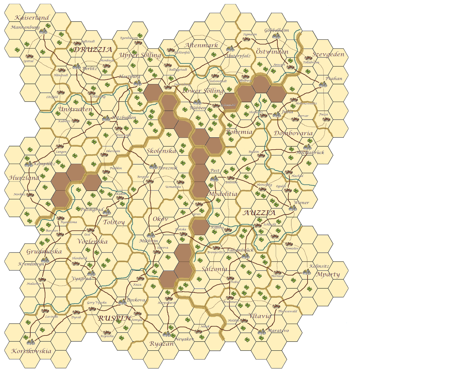
The campaign will be an 'imagi-nation' campaign - it will take place in a fictional land. This land is the subject of this post, because I've just finished the map. It features the three countries - it's fairly easy to see which is which - each with eight provinces. Each province has a provincial capital and a number of small towns.
The map shows major rivers, major roads and minor roads. It also shows terrain density. I wanted a simple way to give players an idea what kind of terrain would probably be found in each hex - because dense terrain, in war games terms at least, is usually easier to defend. I will draw up quite a few of random battlefield set ups prior to the start of the campaign (probably 12) which I'll permanently assign to a hex, and replace, after use. These set ups will have a range of terrain densities. I will grade each battlefield for density and assign it a number. The higher the density the higher the number. When two armies meet a dice will be rolled (probably D8). The number of clumps of trees in the hex will modify the roll - none no modifier, one modify by +2, two modify by +4. A density of 1 will be a gently rolling landscape with an occasional copse and village, 12 might look like the Alps! Terrain, such as hills, will then be graded for steepness, etc., so even if the player rolls a 1 in a hex with two clump of trees - result 5 - he knows what he gets will be difficult terrain - the hills will probably be steep and the woods dense. This grading system is the reason the campaign map does not feature minor rivers. Rivers will be featured, as a matter of course, on some of the battlefields. Major rivers can be overlaid on any battlefield if the attacking player fails a test to bypass the defender (this will not be easy). Alternatively, I might look at the terrain system in Warfare in the Age of Reason / Sport of Kings, which could be made to work in a similar way (I think) - we shall see.
Anyway, enough of my twaddle - when the rules are done I'll make them available. Here is the map. The space at the side is for the legend, compass rose, and a few 'quick play crib tables' that I'll add when the rules are finished.
The map was made using the MS Paint app in Windows 8.1.
First I googled all the bits I needed - the hex grid, the towns, trees and stuff. I worked out my fonts and made a note of sizes (this is actually quite important, because it is the easiest thing to lose track of and forget). I reduced the size of some images to fit the map (see below). I placed these things in the space at the side of the map - which I'll use later for tables and things.
Then I took the hex grid section (about ten by eight) and cut, joined and pasted, until I had sufficient hexes. Then, and this sounds wierd, I bulk filled the hexes with three colours, counting out hexes, so that each state was the same in area (I think 120 hexes each - give or take the odd mistake). Thus the shape of the countries was formed. I then unfilled the border hexes, to clear, and added the main state boundaries, a few hexes at a time to keep a track of where they went.
From this point on it was a matter of filling the provincial capital squares and drawing the provincial boundaries. Then I filled the areas with the tan base colour, and added the 'mountains' and rivers.
From that point on it was simply a matter of cutting and pasting the trees and villages, etc. The new paint app allows you to change the size of things within the page (I couldn't do this before?) - which was especially useful for reducing the size of the tree clumps and town images: These were more than twice the size they are now. I added everything in this order: Provincial capitals; small towns; roads - major then minor; tree clumps; names.
Names were done for each state in the side section and dragged into position. I used an Atlas for reference, and changed letters and joined place names together until I had a list of names - I did more than required and chose the best.
Apart from cut and paste, the most used tool was magnification - when using a mouse big is best to do stuff, small is best to see stuff. The new resize function was also much appreciated as it would have been a pain to have to do the villages and trees from scratch at the right size.
I hope this answers any questions on the 'how'.
4 comments:
Nice map, I like the names!
This will be great to watch develop - looking forward to the intrigue and battle reports with gorgeous units.
Have you used special software for the map?
Thanks
That question has been asked twice now, so I'll go back into the post and edit in a short description of what I did.
The map was made using the MS Paint app in Windows 8.1
I went from XP to 8, so I'm unsure when this version of paint, with transparency, came out.
Thanks James
Post a Comment